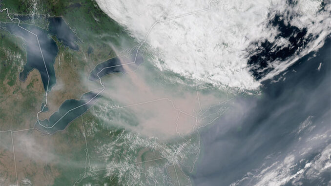
The eastern Canadian provinces are far to the north of most US cities. So how could a lightning strike, sparks from a train’s brakes, or a discarded cigarette in Quebec or Ontario cause major problems in Chicago, New York, Washington D.C., or Philadelphia?
These actions are leading causes of wildfires in Canada. This summer, a series of fires have raged through Canada. The fires have burned thousands of acres of forests. They have claimed the lives of three firefighters. Massive plumes of smoke from the fires travelled across the continent.
The smoke contains pollutants such as carbon monoxide, carbon dioxide, and particulate matter. These pollutants cause health risks, ranging from itchy eyes and sore throats to asthma and respiratory diseases. Millions of people across the country were advised to limit their time outdoors. In New York and Philadelphia, Major League Baseball postponed games. Airports shut down because of a lack of visibility.
Wildfires are not new to Canada. However, this year they have been more frequent. They have also been much more difficult to control. Canada had a very low amount of snowfall this winter, and a very dry spring. With warm temperatures this summer and dry forests, the conditions made it very easy for fires to start. The Canadian Forest Service believes that trees knocked over by Hurricane Fiona last fall served as fuel for the fires. This made them harder to control.
Major fires in California, Australia, Canada, and Maui have shown that wildfires are becoming more frequent and severe. Climate change has caused the warmer, drier conditions that have led to this. While the effects of Canadian wildfires reached far, the effects of climate change are reaching even further.
What Can You Do? Think about your daily activities. Do they have consequences beyond your community?
Photo Credit: NASA Earth Observatory image by Lauren Dauphin, using GOES 16 imagery courtesy of NOAA and the National Environmental Satellite, Data, and Information Service (NESDIS).


